Flood Management Plan Newcastle: A Straight-Talking Guide for Hunter Region Developers
If your Newcastle property sits near the Hunter River, Throsby Creek, or any low-lying part of the city, read this before you lodge your DA. A flood management plan for Newcastle is not just bureaucratic paperwork. It is the document that tells the council your development understands the flood risk on your site — and manages it properly. Without it, most Newcastle development applications in flood-affected areas will not progress past the initial assessment stage.
R I Eng Pty Ltd prepares flood management plans for Newcastle City Council and the surrounding Hunter region LGAs. Here is everything you need to know before you start.
Why Newcastle Takes Flood Risk So Seriously
Newcastle has a flood history that most developers cannot afford to ignore.
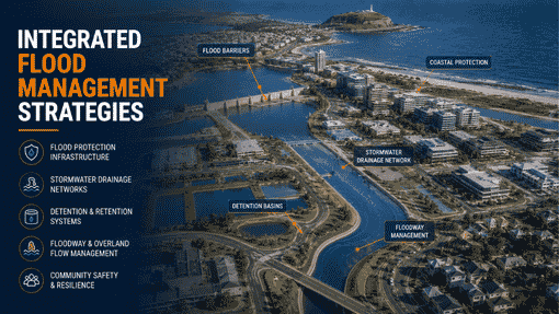
The Hunter River is one of Australia’s most flood-prone major waterways. Its catchment covers a vast area of inland NSW. When heavy rainfall hits that catchment, water moves toward Newcastle — and the city has experienced damaging flood events multiple times over the past century.
But river flooding is not the only concern. Suburbs like Hamilton, Mayfield, Waratah, and Wickham also deal with localised stormwater flooding when the drainage network cannot keep up with intense rainfall. Coastal suburbs face a third layer — tidal influence and the risk of coastal inundation during severe weather events.
A flood management plan for properties in these areas in Newcastle must address all three mechanisms. That is not a minor document. It requires genuine hydraulic engineering experience to get right.
Newcastle City Council has tightened its flood planning requirements noticeably over the past decade. More sites now fall within defined flood planning areas than before. More development types now trigger a flood report requirement. Getting ahead of this early — before your DA is lodged — saves significant time.

What a Flood Management Plan Newcastle Actually Covers
A flood management plan for Newcastle is a technical report that answers a specific set of questions the council needs answered before granting approval.
Those questions include:
What is the flood hazard level on this site?
The report identifies whether the site falls in a low, medium, or high flood hazard category under Newcastle’s planning framework. This determines what construction standards apply.
What floor and ground levels are required?
The flood planning level (FPL) sets the minimum height for habitable floor levels and, in some cases, finished ground levels. Getting this wrong at the design stage creates serious problems later — sometimes forcing redesigns after DA approval.
What construction materials and methods are flood-compatible?
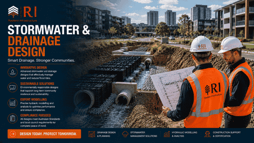
Below the FPL, specific material and construction requirements apply. The flood management plan for Newcastle documents these requirements so your architect and builder know exactly what to design and specify.
Will the development worsen flooding for anyone else?
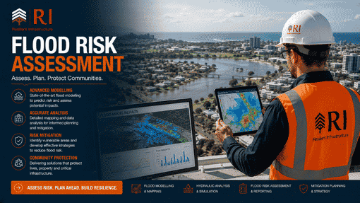
Council needs confirmation that your development will not increase flood levels or velocities on neighbouring properties or in the broader catchment. For some sites, hydraulic modelling is needed to answer this question properly.
Are there evacuation considerations?
High-hazard sites need an assessment of whether safe pedestrian access is available during the design flood event.
R I Eng addresses every one of these points in a structured report format — one that Newcastle City Council’s assessment team can work through efficiently.
Newcastle Coastal Sites: An Extra Layer of Complexity
Properties near Newcastle’s coastline, the harbour, and tidal reaches of Throsby Creek face a more complex flood picture.
Tidal levels interact with stormwater drainage capacity. During a major coastal storm, drainage outlets that normally work well may be submerged by elevated tidal water. This backs up the internal drainage system and can cause flooding well away from the waterfront.
A flood management plan for Newcastle for coastal or near-tidal sites needs to account for this interaction. R I Eng has the hydraulic engineering experience to model these scenarios correctly and prepare a flood report that gives the council a complete picture of the risks and how the development addresses them.

How R I Eng Prepares Your Newcastle Flood Management Plan
Our process is straightforward. Here is what happens after you contact us.
First, we review your site address against Newcastle City Council’s flood mapping. This tells us the applicable flood planning level, flood hazard category, and any special flood provisions in the DCP that apply to your area.
Next, we collect your survey data and review the proposed development layout. We check finished floor levels against the FPL, identify any overland flow path conflicts, and determine whether hydraulic modelling is required for your site.
Then we prepare the flood management plan for Newcastle. The report covers flood hazard assessment, floor level compliance, construction requirements, catchment impact assessment, and evacuation considerations where applicable. Where DRAINS modelling is required, we run the model and include the outputs.
The finished document is structured for council assessment — clear headings, direct answers to the DCP assessment criteria, and a concise summary upfront. We do not pad flood reports with unnecessary material. Council assessors appreciate that.
Most flood management plans for Newcastle residential sites are ready within five to seven business days. Complex sites involving hydraulic modelling take a few days longer. We tell you upfront what your timeline looks like.

FAQ About Flood Plans
Q: How do I know if my Newcastle property needs a flood management plan?
Check your Section 10.7 planning certificate — it lists flood planning information for your property. You can also check Newcastle City Council’s online mapping tools. If either shows your property is in a flood planning area, a flood management plan for Newcastle will be required. If you are still unsure, send us your address. We can confirm within the day.
Q: Does the Hunter River floodplain affect every Newcastle property?
No. The flood planning areas in Newcastle cover specific locations based on detailed flood studies. Properties near the Hunter River, local creeks, and low-lying drainage paths carry the highest risk. Many Newcastle properties sit well outside flood planning areas and need no flood documentation at all. The answer depends entirely on your specific address.
Q: Can a flood management plan actually remove flood restrictions from my property?
Yes — in some cases. If a site-specific hydraulic assessment demonstrates that your property sits above the applicable flood planning level, that finding can support an application to review or remove the flood designation. This does not work for every property.
Q: Does R I Eng prepare flood reports for councils outside Newcastle City Council?
Yes. R I Eng prepares flood management plans for Lake Macquarie Council, Maitland City Council, Port Stephens Council, Cessnock City Council, and other Hunter region LGAs. Each council has its own flood planning framework. We apply the correct requirements for whichever council your project falls under.
Ready to Get Your Newcastle Flood Report Sorted?
📞 Call R I Eng Pty Ltd: +61 0451 452 932
📧 Email: riengineering2155@gmail.com
🌐 Website: riengineering.com.au
Flood documentation does not need to be a roadblock. With the right engineering team on your side — one that knows Newcastle’s flood planning framework and has prepared reports for councils across the Hunter region — it becomes another box ticked on the way to your approval.
Call or WhatsApp us today. Tell us your site address and what you are planning to build. We will take it from there.